The ISA welcomes visiting flyers and guests, however we would ask you to follow some simple rules to ensure our continued use of the site.
The ISA and the National Trust
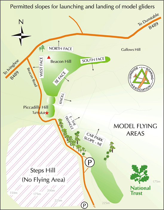
The Ivinghoe hills are a public site managed by the National Trust. The ISA holds a paid licence to fly there, however the licence restricts us to flying unpowered models only, and in specific areas - see map below.
Safety is paramount. In particular, the hills are often busy with walkers, and it's imperative to be aware of other users.
Rules for flying
All flyers are required to observe the following:
Carry your BMFA card
- Please carry your BMFA membership card with you. You may be asked to produce it, as flying without BMFA insurance is strictly prohibited. You can join the BMFA directly
Gliders only
- Only unpowered models may be flown. If you wish to fly a power model, it must be flown as a glider (the propeller must be removed, or secured to the sides of the fuselage).
- Combat flying is strictly prohibited.
Frequency control
- Pilots flying on 27/35 MHz are required to use a pegboard (ISA members must bring one with them). The 'peg-off' convention is used, i.e. the peg for your frequency should be removed from the board.
- For frequency awareness reasons, pilots must always fly from the same slope. This applies also to pilots using 2.4 GHz. If there is a choice of slope, check to see if anyone has already arrived, and if so go and join them. For example, in a NNE wind there is a choice of either the North Face or Car Park slopes - see map.
General safety
- If you are a novice, please seek advice from an experienced pilot before first switching on your transmitter.
- Flyers must be mindful of other users, particularly when launching and landing.
Please make yourself known, and don't hesitate to ask any questions - we're a friendly bunch!
Permitted slopes
There are slopes for West, North, North East and South (see map below). The West slope is the best.
Flying is not permitted from Steps Hill - the area is reserved by the National Trust to encourage wild flora and fauna. There is also a warning sign to stay on the paths due to the potential danger from live munitions.
How to get there
Please check the home page for closure warnings.
Emergencies
The grid references for emergency services (999) are:
- NT Main (Beacon) car park: SP 9635 1590
- Trig point on top of west face: SP 9595 1685
You may wish to carry a whistle, in case of slips or falls on the slope.
Further information
If you have any questions regarding the use of Ivinghoe hills for slope flying, please do not hesitate to contact a member of the committee. If you fly regularly, then do join the ISA and enjoy the many benefits!